More fun warnings from the National Weather Service! They sure like to try to scare the bejebus out of you don't they?
Severe weather alert from the national weather service ...hurricane charley local statement national weather service tampa bay area - ruskin fl 538 pm edt thu aug 12 2004
... Intensifying hurricane charley may be a dangerous threat to the suncoast friday... ... Hurricane warnings issued for areas south of bayport...
A hurricane warning has been issued for the following locations in west central and southwest florida:
Charlotte de soto hernando hillsborough lee manatee pasco pinellas sarasota including... The coastal waters from bonita beach to bayport... Charlotte harbor and tampa bay.
A hurricane watch continues for the following locations in west central florida:
Citrus levy
Including... The coastal waters from bayport to the mouth of the suwanee river.
An inland hurricane wind watch is in effect for the following locations in west central florida:
Hardee highlands polk sumter
... Storm location... At 5 pm edt... The center of hurricane charley was located near 21.2 north... 81.9 west... Or about 465 miles south of tampa. Charley was moving to the north northwest at 18 mph... And is expected to gradually turn to the north over the next 24 hours. Maximum sustained winds are near 105 mph... And additional strengthening is expected as the storm moves out of the caribbean and into the gulf. Charley could become a major hurricane later tonight or friday. Minimum central pressure was 980 mb... 28.94 inches.
... Storm surge flood and storm tide impacts... With charley expected to intensify... Then accelerate... Along the suncoast... The threat of a rapidly developing storm surge in the storm's southern semicircle is great. Current indications suggest the highest surge will occur from the counties near tampa bay south to lee county. The current forecast track... Speed... And intensity suggest storm surges in some areas equaling or exceeding those experienced in hurricane donna in 1960 and the 1944 hurricane each of which made landfall north of fort myers... Or more likely the 1921 hurricane which made landfall in northern pinellas county.
A storm surge of 10 to 13 feet is possible to south of where charley makes landfall.
... Wind impacts... Charley is forecast to intensify and could become a category three hurricane as it approaches the suncoast on friday... With winds in the inner eyewall perhaps at least 130 mph with higher gusts. However... No matter where the center crosses... Current forecast data suggest tropical storm force winds of at least 40 mph will affect all areas of west central and southwest florida between friday early saturday.
... Very dangerous winds will produce widespread damage... ... Destruction of mobile homes near the center of the storm is possible...
... Structural damage... The majority of mobile homes will be severely damaged near where the storm makes landfall. Houses of poor to average construction will have significant damage... Including partial wall collapse and roofs being lifted off. Many will be uninhabitable. Well constructed houses will incur minor damage to shingles... Siding... Gutters... As well as blown out windows.
Partial roof failure is expected at industrial parks... Especially to those buildings with light weight steel and aluminum coverings. Older low rising apartment roofs may also be torn off... As well as receiving siding and shingle damage. Much of the glass in high rise office buildings will be blown out. Airborne debris will cause damage... Injury... And possible fatalities.
... Natural damage... All trees with rotting bases will become uprooted or snap. Nearly all large branches will snap... And major damage is can be expected to citrus groves... Including numerous uprooted trees... Most common where the ground is saturated.
The next hurricane local statement from the tampa bay area forecast office will be issued around 9pm edt.
Stay tuned to noaa weather radio for further information on this dangerous flood. Heed all evacuation orders from law enforcement or military personnel.
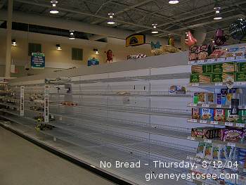
In other news, we just got back from the supermarket. No panicking here, just needed some dinner tonight and some food for tomorrow. Oh and some t.p. That's vital stuff to have. There were actually empty shelves. No bread at all and no water in site. The canned soups were pretty picked clean as well. Yours truly had her trusty camera with her and can show you what I mean.

No bread. None. Nada. Not even hotdog buns.

No water. Nothing bottled nor in gallon anywhere in the store.
At the moment the weather is HOT. It's also extremely BRIGHT and SUNNY outside. The humdity is way up there. No signs of rain clouds and no rain to speak of. The small shower earlier has not only disappeared, the water it left has already evaporated.
So that's the latest. I'm off to eat.